The story of Walden
Nine centuries of a walled-in market town, era by era. Every era links to the interactive map, where you can watch the town grow.
Open the map ❄ Walden Christmas gifts
Castle & market town 1086–1399
Domesday Book (1086) records Waledana with 147 households, already among the largest fifth of places in England; the name is Old English and older Saxon finds come from Abbey Lane. Under the de Mandevilles came the castle, a priory (1136 in the Victoria County History; English Heritage gives 1139) and, in 1141, the market moved here from Newport. In the 1230s the de Bohuns laid out a new grid of streets, market place and church, and the town was ringed by the Magnum Fossatum, the Great Ditch.
Sources: Open Domesday: Saffron Walden · Saffron Walden Museum: local archaeology · Victoria County History, Essex vol. 2, pp. 110–15 (British History Online) · Visit Saffron Walden: Town Trail (PDF) · Heritage Gateway: Repell Ditches
- 1086Domesday records Walden: 147 households — among the largest fifth of settlements in England — with 42 plough teams, woodland for 830 pigs, meadow, mills and beehives. Worth £36 under Esger the constable in 1066; £50 under Geoffrey de Mandeville by 1086. Open Domesday
- 1136Geoffrey de Mandeville founds Walden Priory beside his castle town; it is raised to a full abbey in 1190. Victoria County History
- 1141The market charter: Empress Maud's grant moves Newport's market to Walden — and the Tuesday and Saturday markets still trade under it today. SW Town Council
- 1200sThe Magnum Fossatum — the 'great ditch' — is dug around the growing town, enclosing some 20 hectares. The Battle Ditches are its surviving corner. Historic England
- 1300sWool is the town's principal trade, with the wool-staplers' guild hall standing in the marketplace — and in the fields, saffron growing begins in the reign of Edward III. Recording Uttlesford History
- by 1141; slighted 1157–58Walden Castle: The flint-rubble core of a Norman tower keep beside the Museum, first recorded in 1141 in the hands of Geoffrey de Mandeville. See it on the map
- 1141Market Place: Saffron Walden has held a market since 1141, when Empress Maud's grant let Geoffrey de Mandeville move Newport's market here. See it on the map
- 13th c. onwardsThe Rows: Butcher Row, Market Row and Mercers Row follow the lines of medieval market stalls grouped by trade, slowly replaced by permanent shops and homes. See it on the map
- c.1250–1350Battle (or Repell) Ditches: The surviving south-west corner of the Town Ditch, called the Magnum Fossatum (Great Ditch) in medieval documents and later the Repell or Battle Ditches: one earthwork, several names. See it on the map
- medieval; recut 1699The Turf Maze: Thought to be medieval, this is the largest surviving historic turf labyrinth in Europe: 17 rings of path cut into the turf at the east end of the Common. See it on the map
- medieval Castle GreenThe Common: The town's oldest open space, once called Castle Green, is legally a registered village green of about 14 acres. See it on the map
- 14th c.; pargeting 1676The Old Sun Inn: Once the Sun Inn, this Grade I timber-framed range on the corner of Church Street and Market Hill dates from the 14th century. See it on the map
- 15th c.The Eight Bells: A 15th-century timber-framed inn on Bridge Street with late-16th-century additions, jetties and pargeting. See it on the map
- 15th–16th c.Cross Keys: A timber-framed corner inn at High Street and King Street, with 15th- and 16th-century fabric behind its later fronts. See it on the map
1086: the Domesday manor and the town's names
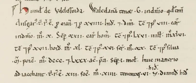
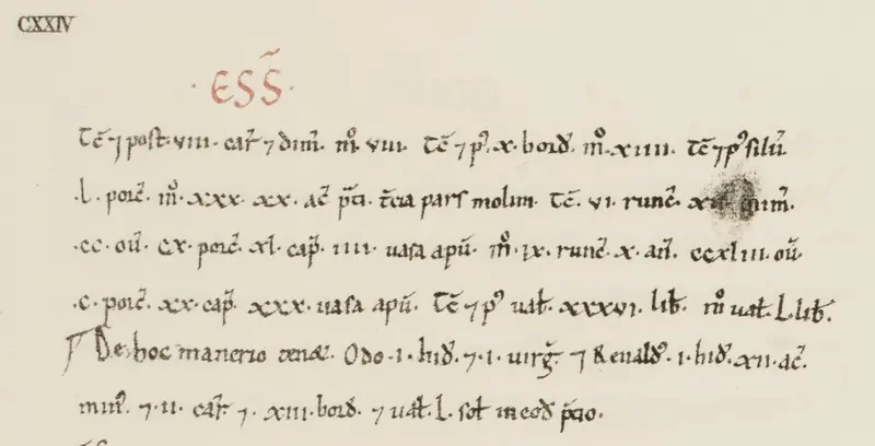
In 1086 Walden was already a big place: 147 households — 46 villagers, 14 freemen, 67 smallholders and 20 slaves — putting it in the largest fifth of settlements in Domesday. It ran 42 plough teams, 100 acres of meadow, woodland feeding 830 pigs, mills and beehives; worth £36 in 1066 under Esger the constable, £50 by 1086 under Geoffrey de Mandeville.
| Form | When | Source |
|---|---|---|
| Waledana | Domesday, 1086 | Old English wealh + denu — 'valley of the Britons' — Open Domesday / Key to English Place-Names |
| Waldenburgh | 'at a latter period' | Lewis's Topographical Dictionary, 1848 |
| Cheping Walden | after the 1141 market | chepyng = market — Lewis, 1848 |
| Magna Walden | 1484 | Court of Common Pleas, Hilary Term — reported via Wikipedia's citation, not checked against the roll |
| Saffron Walden | sealed 1514 | Henry VIII's charter, decorated with saffron flowers — Visit Saffron Walden |
Saffron town 1400–1599
By the late 1300s the fields around Walden grew the saffron crocus, and by the early 1500s the town was the centre of the English saffron industry. Henry VIII's charter of 1514, its initials decorated with saffron flowers, marks the change from Chipping Walden to Saffron Walden. The wealth shows in the timber-framed houses of the period and in St Mary's, completed in 1525.
Sources: Visit Saffron Walden: Town Trail (PDF) · Visit Saffron Walden: The Saffron Crocus
- 1514Henry VIII's charter — its initial letters decorated with saffron flowers — seals the change of name: Chipping Walden becomes Saffron Walden. Visit Saffron Walden
- 1490s1 Myddylton Place: A timber-framed merchant's house, shop and warehouse of the 1490s with a carved dragon post, long the town's youth hostel and Grade I listed. See it on the map
- 1521–22The Grammar School, Castle Street: The town's grammar school was teaching in Castle Street by 1521–22, founded by the Guild of the Holy Trinity and Dame Joan Bradbury. See it on the map
Abbey to palace & Civil War 1538–1699
Walden Abbey surrendered to the Crown on 22 March 1538 and passed to Sir Thomas Audley; from about 1605 the Earl of Suffolk rebuilt it as Audley End, the most ambitious house of its day. In spring 1647 Sir Thomas Fairfax made the town the New Model Army's headquarters, and debates in St Mary's saw ordinary soldiers elect representatives for the first time. The town itself grew little in the 17th and 18th centuries as the saffron trade declined.
Sources: English Heritage: History of Audley End · Visit Saffron Walden: Town Trail (PDF) · SW Historical Society: Saffron Walden and the Struggle for Democracy (S. Newens, 2005)
- 1538Walden Abbey is surrendered to the Crown on 22 March and granted to Lord Chancellor Sir Thomas Audley five days later — the seed of Audley End. English Heritage
- 1647The New Model Army makes Saffron Walden its headquarters; on 6 May Oliver Cromwell meets the army's officers inside St Mary's church — a step on the road to the Putney Debates. SW Initiative
- 1660Samuel Pepys stables at the White Hart on 27 February, tours Audley End, and in the old abbey cellars drinks 'most admirable drink, a health to the King'. The Diary of Samuel Pepys
- 1667Charles II buys Audley End for £50,000 — a royal palace again, chosen for its convenience to the Newmarket races; the crown hands it back in 1701. English Heritage
- 1685James II gives the town its great mace, engraved with an early version of the saffron-flower device. SW Town Council
- 1139 → todayAudley End: abbey to palace: Walden Abbey became Audley End, and the house has been shrunk, remodelled and restored ever since. See it on the map
- May 1647The Army debates, May 1647: In spring 1647 Sir Thomas Fairfax made Saffron Walden the New Model Army's headquarters, with soldiers billeted in the town and villages. See it on the map
- 1647 traditionCromwell at the Sun Inn? (legend) (legend): Local tradition says Oliver Cromwell stayed at the Sun Inn in 1647, and a sign there once called it his headquarters. See it on the map
- traditionThe Cross Keys footsteps (legend) (legend): Marching footsteps are said to pace a passage of the Cross Keys each Christmas Eve before midnight, attributed to a Cromwellian soldier. See it on the map
- 1676; rebuilt 1879Friends Meeting House, High Street: Quakers have met on this High Street site since 1676, when a cottage's back room became their meeting room. See it on the map
Audley End, from abbey to English Heritage
- 1136/1139Geoffrey de Mandeville founds a Benedictine priory at Brookwalden by the Cam (1136 in the Victoria County History; English Heritage gives 1139).
- 1190The priory is raised to an abbey; the de Bohuns are its patrons from the 13th to the 15th century.
- 1538The abbey surrenders to the Crown on 22 March and is granted five days later to Lord Chancellor Sir Thomas Audley, who turns it into his 'chiefe and capital mansion house at Walden'.
- c.1605–14Thomas Howard, 1st Earl of Suffolk, rebuilds it on the scale of a royal palace; James I visits twice in 1614.
- 1667Charles II buys the house and park for £50,000, drawn by the Newmarket races. It is handed back to the Suffolk heirs in 1701.
- 1708–1750sSuccessive earls reduce the house to its inner court (John Vanbrugh 1708, Nicholas Dubois c.1725); after 1751 the Countess of Portsmouth demolishes the long-gallery east range.
- 1762–97Sir John Griffin Griffin brings in Robert Adam for new rooms and Capability Brown to remodel the grounds.
- 1820s–30sThe 3rd Lord Braybrooke sets out to recover the house's Jacobean character; William Gilpin lays out the parterre.
- 1941–48Requisitioned in 1941, it becomes headquarters of SOE's Polish Section; in 1948 it is bought for the nation.
- 1984English Heritage takes over care, focusing on research, repair and restoration of the kitchen garden, service wing and parterre.
Sources: English Heritage: History of Audley End · Victoria County History, Essex vol. 2, pp. 110–15 (British History Online)
Saffron Walden and the New Model Army, 1647: fact and legend
In spring 1647 Sir Thomas Fairfax made Saffron Walden the New Model Army's headquarters, with soldiers billeted in the town and villages. Parliament's commissioners met some 200 officers in the church, and in late April each troop and company chose two 'agitators' to speak for it, a first. On 6 and 7 May, and again on 15 May, Skippon, Cromwell, Ireton and Fleetwood met the officers here before the army refused to disband and marched to Newmarket. SW Historical Society: Saffron Walden and the Struggle for Democracy (S. Newens, 2005)
Local tradition says Oliver Cromwell stayed at the Sun Inn in 1647, and a sign there once called it his headquarters. The Saffron Walden Historical Society notes there is no proof that he stayed here. What is documented is that Fairfax's army made the town its headquarters that spring. SW Historical Society: Saffron Walden and the Struggle for Democracy (S. Newens, 2005)
Marching footsteps are said to pace a passage of the Cross Keys each Christmas Eve before midnight, attributed to a Cromwellian soldier. A ghost story, recorded as such. Paranormal Database: Essex
Georgian town 1700–1836
Commercial saffron growing died out around 1790 and malting took over. The Georgian Town Hall went up in 1761, Capability Brown and Robert Adam remade Audley End from the 1760s, and in 1832 the King's Ditch was culverted under the streets. The 1830s brought the museum, the rebuilt almshouses and the union workhouse.
Sources: Recording Uttlesford History: Saffron Walden · Visit Saffron Walden: Town Trail (PDF) · English Heritage: History of Audley End · SW Historical Society: The Walden Slades (J. Cooper, 2007)
- c. 1790Commercial saffron growing dies out, undercut by imports, and malt takes over — more than 40 maltings work in the town by 1800. Recording Uttlesford History
- 1824–96The Quaker century: the Gibsons found their bank in 1824 and steer it into the founding of Barclays in 1896, while George Stacey Gibson — mayor 1875–77 — pays for the fountain, the Corn Exchange, the Town Hall front and the Friends' School site. Barclays archive
- 1761; front 1879Town Hall: Built in 1761 and given its timbered front in an 1879 extension by Edward Burgess, paid for by the Gibsons. See it on the map
- 1763Capability Brown's 'wrong bend': In 1763 Sir John Griffin Griffin hired Lancelot 'Capability' Brown to widen and reshape the Cam through the park for £660. See it on the map
- 1760sTea House Bridge: Robert Adam designed the Palladian Tea House bridge among the garden buildings for Sir John Griffin Griffin's new landscape. See it on the map
- 1834–35Saffron Walden Museum: Built for the town's Natural History Society and opened in May 1835, one of the oldest purpose-built museums in the country. See it on the map
- 1834–81King Edward VI Almshouses: Almshouses rebuilt by the Gibson family: central block and chapel 1834, east wing 1840, west block 1881, continuing a much older charity. See it on the map
- 1835–36The Union Workhouse: Built in 1835–36 for a union of 24 parishes to James Clephan's design, for up to 340 people. See it on the map
- 1832The King's Ditch culvert: The King's Ditch, the town's stream or Slade, was covered over piecemeal from perhaps 1650, and the brick culvert under the centre dates from 1832, when Market Street was widened and the ford at Bridge End got a road bridge. See it on the map
Quaker & railway town 1837–1913
Prosperity returned with malting, brewing and farming, and the Quaker Gibson family of bankers and brewers helped found the museum, the library and the hospital, brought the Friends' School to the town and, in 1865, the railway branch line. Victorian growth spread south of the old centre towards the station and London Road. The 1890s outline is traced from the Ordnance Survey six-inch map.
Sources: Visit Saffron Walden: Town Trail (PDF)
- 1865–1964The railway age: the branch line opens on 23 November 1865 and dies with Beeching on 7 September 1964 — the station building survives as housing. Wikipedia
- from c.1837Bridge End Garden: A rare late-Regency and early-Victorian garden, created mostly from about 1837 by the Quaker Francis Gibson behind his family's Bridge Street business. See it on the map
- Victorian; replanted 1984The hedge maze, Bridge End: By 1983 the Victorian yew maze was little more than an overgrown spinney. See it on the map
- 1847–48Corn Exchange (the library): Built around 1847–48 on the site of the medieval wool-staplers' guild hall, demolished that year; its classical front now leads to the town library. See it on the map
- 1832; here since 1853The Gibson Library: Founded in 1832 as the Literary and Scientific Institution, the library has been at 2 King Street, joined to the Corn Exchange, since 1853. See it on the map
- 1824 / 1874 / 1896Gibson's Bank (Barclays): The Quaker Gibsons' bank, founded in 1824, moved into this Gothic red-brick building by W. See it on the map
- 1862–63The Market Place fountain: Designed in 1862 by J.F. See it on the map
- Gibson era; reopened 1987Fry Art Gallery: Built to house the art collection of the Quaker Francis Gibson, it reopened in 1987 as the Fry Public Art Gallery. See it on the map
- 1865–1964The old railway station: The Gibsons helped bring the branch line to the town in 1865; it closed in 1964. See it on the map
- 1845Audley End station: The town's main-line station is about 2 miles away in Wendens Ambo. See it on the map
- 1865–66The old hospital (council offices): Saffron Walden General Hospital, built 1865–66 in High Victorian Gothic with a £5,000 bequest from the Quaker Wyatt George Gibson. See it on the map
- 1879–2017Friends' School: The Quaker school founded in London in 1702 moved to these purpose-built red-brick buildings in 1879, on a site given by George Stacey Gibson. See it on the map
- 1884–1977The Training College: Opened in 1884 as a Ladies' Training College for teachers, financed by George Stacey Gibson. See it on the map
- 1913The water tower, Debden Road: A 28-metre red-brick water tower of 1913, designed by A.H. See it on the map
- 1836 / 1862The old waterworks, Hill Street: The town's first public water supply came from deep wells paid for by Jabez Gibson, at waterworks in Hill Street where the fire station now stands. See it on the map
Wars & the 20th century 1914–1999
The war memorial of 1921 names 159 townsmen lost in the First World War. In the Second, Audley End became the headquarters of the Special Operations Executive's Polish Section and the USAAF 65th Fighter Wing was based in the town. The branch line closed in 1964 and large housing developments grew on the outskirts; the map keeps the 1890s outline for this era because no outline from these years has been traced yet.
Sources: Historic England list entry 1297763 · English Heritage: History of Audley End · Saffron Walden Town Council: Anglo-American Memorial Playing Fields · Visit Saffron Walden: Town Trail (PDF)
- 1961The College of Arms grants the town its coat of arms: three saffron flowers rising from the battlements of a gateway — an official heraldic pun on 'Saffron walled-in'. SW Town Council
- 1969Fire destroys the Rose & Crown on the Market Place in the early hours of Boxing Day, killing eleven — the disaster that drove the Fire Precautions Act 1971. Saffron Walden Museum
- 1990One of Britain's last council nuclear bunkers is completed in the basement of the old hospital on London Road — £375,000, still fully equipped. Subterranea Britannica
- 1921The War Memorial: Unveiled on 7 May 1921 by General Lord Horne, designed by T.J. See it on the map
- 1941–45Audley End: the Polish SOE station: Requisitioned in 1941, Audley End served as the headquarters of the Polish Section of the Special Operations Executive, training agents for occupied Europe. See it on the map
- 1954–55Anglo-American Memorial Playing Fields: Playing fields opened in 1954, with a memorial dedicated in 1955 to every man of the USAAF 65th Fighter Wing, headquartered in the town, who died in the Second World War. See it on the map
- opened 1953Saffron Walden County High School: The County High School opened on Audley End Road in 1953 and, in the Hundred Parishes' words, 'has grown and grown'. See it on the map
- 1969Site of the Rose & Crown: The Rose & Crown inn, recorded from 1359, stood on the east side of the Market Place until fire swept it in the early hours of 26 December 1969, killing eleven. See it on the map
- 1990The Cold War bunker: In the old hospital's basement is the Uttlesford emergency centre, one of the last local-authority nuclear bunkers built, finished in 1990 for £375,000. See it on the map
Walden today 2000–now
The outskirts have kept growing with large modern estates and infill in the centre, and the town has a population of about 15,000 by the Town Trail's count. Saffron Hall opened in 2013, repairs to the castle keep were finished in 2021, and the former Friends' School is being turned into homes in 2026.
Sources: Visit Saffron Walden: Town Trail (PDF) · Hundred Parishes: Saffron Walden (PDF)
- 2013Saffron Hall: A concert hall on the County High School campus, opened in November 2013 with the support of the Yellow Car Charitable Trust. See it on the map
What the street names remember
Only names we could source are here. Switch on the Street names layer to see them on the map.
- Myddylton PlaceA timber-framed merchant's house, shop and warehouse of the 1490s with a carved dragon post, long the town's youth hostel and Grade I listed. The street takes its name from William Myddylton, merchant and churchwarden, named in deeds here from 1474, when the corner was still called Hoggs Green. Historic England list entry 1297805 · map
- Cross StreetThe King's Ditch, the town's stream or Slade, was covered over piecemeal from perhaps 1650, and the brick culvert under the centre dates from 1832, when Market Street was widened and the ford at Bridge End got a road bridge. Cross Street was closed for months in 2005 while a failing stretch was rebuilt. SW Historical Society: The Walden Slades (J. Cooper, 2007) · map
- Gold StreetProbably not gold at all: the name may come from Middle English goule, a ditch or channel, after the King's Ditch that ran this way. SW Historical Society: The Walden Slades (J. Cooper, 2007) · map
- King StreetAfter the King's Ditch was culverted, its name is thought to have transferred to the street beside it. SW Historical Society: The Walden Slades (J. Cooper, 2007) · map
- Castle StreetWith Church Street it follows the castle's outer ditch, and the name was in use by about 1521, when the grammar school began here. Recording Uttlesford History: Saffron Walden · map
- Bridge StreetOnce Bridge End, after the crossing of the Madgate Slade; the ford was replaced with a road bridge in 1832. SW Historical Society: The Walden Slades (J. Cooper, 2007) · map
- High StreetIts south end was long Cucking Stool End, after the manor court's ducking stool; the Quakers bought a cottage 'at Cucking Stool End' in 1676. Visit Saffron Walden: Saffron Walden Quakers · map
- Winstanley RoadFor Henry Winstanley, baptised here in 1644, who built the first Eddystone Lighthouse in 1698 and died in it in the Great Storm of 27 November 1703. SW Historical Society: Henry Winstanley · map
- Fairycroft RoadNamed for Fairycroft House, the big house at the Audley Road corner on Victorian maps, now a community arts venue. Uttlesford: Saffron Walden Conservation Area Appraisal 2018 (PDF) · map
- Catons LaneFormerly Loft's Lane, renamed around 1900 after William Caton, who farmed the big house down the lane. SW Historical Society: The Meadow · map
- Park LaneShown as Almshouse Lane on the 1843–93 town maps; the almshouses still stand at its corner. Uttlesford: Saffron Walden Conservation Area Appraisal 2018 (PDF) · map
- Radwinter RoadOn the 1891–1912 maps it is Seward End Road, named for where it led, before taking the name of the next village along. Uttlesford: Saffron Walden Conservation Area Appraisal 2018 (PDF) · map
Recorded tales
These are legends: traditions with a written record, told as tales, not facts.
A serpent-creature whose gaze killed, said to have emptied the medieval town until a knight in mirrored crystal armour turned its stare back on itself. Information Britain
Secret passages said to run from No. 4 High Street and from Audley End to St Mary's, from Gloriana Cottage to a bank, and beneath the castle — where an 1881 dig found nothing. Hidden East Anglia
The sarsen boulder at Elm Grove carries the tale of a sheep-thief strangled by his own rope — the groove across the stone said to mark it. Hidden East Anglia
'Legend has it that one of the de Bohuns actually drowned in the Madgate Slade' — the lords of the castle, undone by the little brook at Bridge End. SW Historical Journal 13
On the turf maze, tradition put a maiden at the centre while young men raced the mile of path to reach her — with ale wagered on the outcome; another strand says a soldier re-cut an older design. SW Historical Society
Marching footsteps said to pace a passage of the Cross Keys each Christmas Eve before midnight — attributed to a Cromwellian soldier. Paranormal Database
The Old Sun Inn's resident spirit — 'blamed for moving furniture about, and banging on the walls'. Paranormal Database
A teenage maid said to have frozen to death at Hill House on the High Street in the mid-1800s, and to walk it still. Paranormal Database
Joan Michell of Saffron Walden stands accused of witchcraft in 1579 — the same year a Wimbish woman was said to have bewitched a cradle at Brook Walden. Witch trials record
The Sun Inn's 1676 pargetting freezes the folk tale mid-fight: giant-slayer Tom Hickathrift, armed with axle and cartwheel, facing the Wisbech Giant. SW Museum
On the road to Hadstock, a USAAF pilot is said to appear in the back seats of cars — fifty years to the day after a 1943 crash. Paranormal Database